News Summary
Hong Kong and the Pearl River Delta faced unprecedented rainfall this week, with 356 millimeters recorded, leading to flash floods and significant disruptions. Key services like hospitals and schools were affected, and high winds compounded the chaos with gusts over 90 km/h. A landslip warning has been issued as residents are urged to stay safe amidst this extreme weather, which follows an already wet July and echoes the severe effects of recent tropical cyclones. The situation showed signs of improvement as rain warnings were set to be downgraded later in the day.
Record-Breaking Rains Cause Disruption in Hong Kong and Surrounding Areas
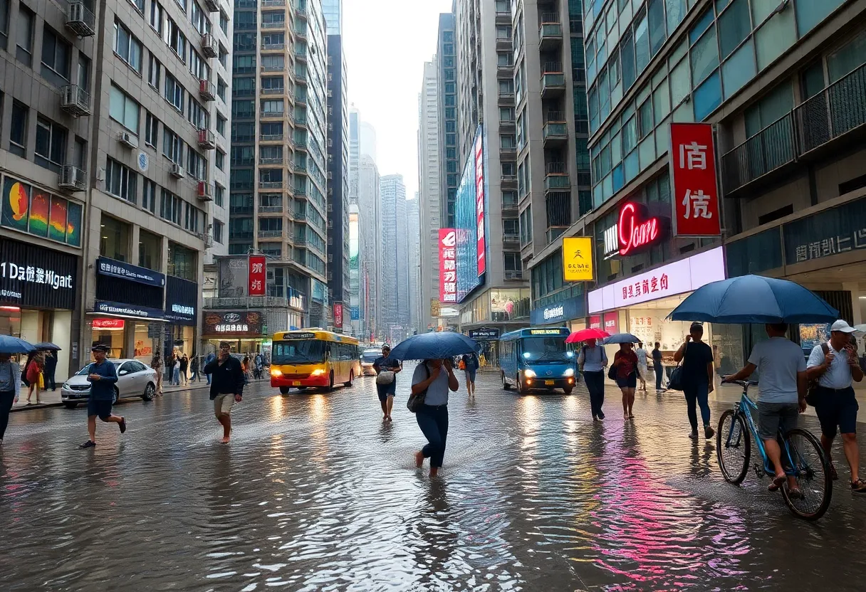
Residents of Hong Kong and the nearby areas of South China’s Pearl River Delta faced an extraordinary weather event this week as the skies turned black and unleashed an unprecedented amount of rain. The Hong Kong Observatory reported that, by 2 p.m. on Tuesday, a staggering 356 millimeters (that’s about 14 inches for those keeping count) of rain had already fallen, smashing the previous daily record for August.
Severe Weather Impacting Daily Life
This torrential downpour was no joke, causing serious disruptions across the city. Hospitals, schools, and law courts found themselves caught in the storm’s wrath. The highest-level rainstorm warning was issued at 5:50 a.m. and remained in effect for much of the day, showing just how serious the conditions were. Flash floods rolled through urban areas like Mid-Levels, Central, Pok Fu Lam, and Quarry Bay, making it quite the challenge for residents.
One particularly hard-hit site was the Queen Mary Hospital, which found itself dealing with muddy floodwaters creeping through its premises. In addition to that, car parks and highways were submerged, leading to chaos on the roads and significant delays for those trying to get from point A to point B.
Stay Alert: Landslip Warnings Issued
As the situation unfolded, a landslip warning was also issued, advising everyone to steer clear of steep slopes and hilly areas to avoid any potential disasters. After all, safety first, right? Adding to the wild weather, violent gusts of wind reaching over 90 km/h (that’s about 56 mph) were recorded in Cheung Chau around 8:35 a.m., making it feel like a scene straight out of a movie!
A Look Back: The Wet Weather Chronicles
Interestingly, July was already setting records for rainfall, with a total of 601.7 mm recorded—an eye-popping 56 percent above normal levels. Much of that was attributed to remnants from tropical cyclone Danas and the later impact of Typhoon Wipha. The effects of Typhoon Wipha on July 20 were particularly severe, causing widespread disruptions that included over 500 flight cancellations, around 33 injuries, and an alarming 2,284 fallen trees.
The first half of 2025 was noted as “very dry,” which only amplified the contrast with the extreme weather this month. With the sky finally opening up after such a prolonged dry spell, it may come as no surprise that the unexpected deluge led to significant fallout.
What’s Next?
As evening approached, there was some relief on the horizon. The Hong Kong Observatory announced that it plans to downgrade its highest rain warning later in the day after an extended nearly 12-hour alert. This may finally bring some peace of mind to residents who endured the weather onslaught.
For many, it’s been a day to remember or forget, depending on how you look at it! Here’s hoping that normalcy returns to Hong Kong soon, and that everyone stays safe and dry in the days to come. 🌧️
Deeper Dive: News & Info About This Topic
- Reuters: Hong Kong Issues Highest Weather Warning
- Wikipedia: Hong Kong
- Bloomberg: Hong Kong Commute Disrupted
- Google Search: Hong Kong weather 2025
- South China Morning Post: Hong Kong Records Rainfall
- Google Scholar: Hong Kong rainfall history
- South China Morning Post: Black Rainstorm Warning
- Encyclopedia Britannica: Hong Kong
- AOL: Black Storm Warning Paralyzes Hong Kong
- Google News: Hong Kong weather alerts

Author: STAFF HERE LOS ANGELES WRITER
The LOS ANGELES STAFF WRITER represents the experienced team at HERELosAngeles.com, your go-to source for actionable local news and information in Los Angeles, Los Angeles County, and beyond, specializing in "news you can use" with coverage of product reviews for personal and business needs, local business directories, politics, real estate trends, neighborhood insights, and state news affecting the area—with deep expertise from years of dedicated reporting and strong community input, including local press releases and business updates, while delivering top reporting on high-value events like the Academy Awards, LA Auto Show, and Los Angeles Marathon, extending coverage to key organizations such as the Los Angeles Area Chamber of Commerce and the Los Angeles Tourism & Convention Board, plus leading businesses in entertainment and technology like Warner Bros. and SpaceX, and as part of the broader HERE network including HEREAnaheim.com , HERECostaMesa.com , HEREHuntingtonBeach.com , and HERESantaAna.com , providing comprehensive, credible insights into Southern California's dynamic landscape. HERE Anaheim HERE Beverly Hills HERE Coronado HERE Costa Mesa HERE Hollywood HERE Huntington Beach HERE Long Beach HERE Los Angeles HERE Mission Viejo HERE San Diego HERE Santa Ana